The Point Richmond History Association Presents:

A Brief History of Point Richmond

by Donna Roselius

Before Our Time...

Long before the industrious white man "discovered" Point Richmond, Indians were enjoying the easy life of this area, living off the bounty of the Bay and creating the shell mounds that researchers have pondered and studied. Early in the 1800's, the Spanish settled here, and Point Richmond became known as The Potrero (pastureland) of the huge Rancho San Pablo owned by Don Francisco Castro. Point Stevens was the next name applied to Point Richmond, appearing on charts of the Bay in 1850. Shortly afterward, Rancho San Pablo was divided among more than 100 land owners, who began developing the towns that eventually emerged. A U.S. Government survey party designated the point of land jutting into the Bay as "Point Richmond". At that time, the point and hilly land attached to it were an island. The waterway separating it from the mainland was government-owned

Tewksbury Found a Gap and Filled It

Jacob Tewksbury, M.D., who came to the Bay Area from Argentina, owned much of the land now occupied by Chevron, USA. He found that sewing up land was more profitable than sewing up people. Though much of his acquired property was marshland, the enterprising Tewksbury constructed levees extending across the waterway, which began a silting process that was assisted by the deepening of channels around Mare Island. When the silt was sufficient to make the island accessible by foot at low tide, Tewksbury petitioned the government to have the waterway declared land, making it available for private ownership.

Macdonald "Discovered" Point Richmond...

In 1895, Augustin Macdonald, who was on a duck hunting trip, took a hike up Nicholl Nob and "discovered" Point Richmond. Noting the breathtaking beauty of the spot, he also noticed the deep water off what we now call Ferry Point, and recognized its potential as the westernmost terminus being sought by Santa Fe Railway Company. And, on July 4, 1900, Santa Fe's first Ferry, the "Ocean Wave" initiated service to San Francisco from its Ferry Point Terminal by carrying a large crowd of revelers over from San Francisco. Santa Fe's tracks, leading through the tunnel to Ferry Point, provided the first 'solid land' connection between Point Richmond and the mainland. Mrs. Emily Tewksbury, who by 1901 was a wealthy widow, made use of her husband's legacy by selling several acres of his previously underwater land to Standard Oil Company. Soon a fast growing refinery completed the closure of a waterway that had served as a shortcut from San Francisco to San Pablo Bay.

Booming Bustling Point Richmond...

The boomtown, now officially part of the mainland town of Richmond, grew faster than buildings could be built. Tents provided temporary housing for Santa Fe and Standard Oil workers while hastily constructed hotels and boarding houses popped up from semi-solid land. The first really permanent building was the Critchett Hotel, at the corner of West Richmond and Washington Avenues (now the site of the Point Richmond Market). When the Critchetts were settled, Mr. Critchett considerately provided a way to get his wife acquainted in her new community. He sent invitations to an afternoon tea to wives of the men he had met here, assuming that the women they had seen in the new town had accompanied his fellow pioneers. Only one guest arrived, the wife of Lyman Naugle, who was publisher and editor of the Point Richmond Record Herald. She was the only other "lady" who had arrived. Boarding houses, bars and bawdy houses were replacing the tents, most of which blew away in the first winter's storms. Insufficient fill on the flatland made streets spongy all winter, and some of the first structures also blew off their shaky foundations. Women who came to join their husbands found it difficult to travel from their new abodes on foot, without high top boots and skirts pulled up beyond usually allowed limits.

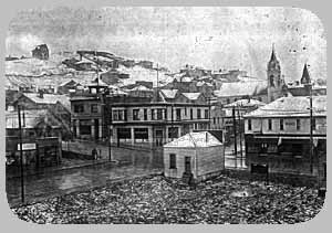
By 1902, downtown Point Richmond was acquiring the necessary amenities -- a fine bank building, opposite the Critchett Hotel at 201 Washington (now "Sherry and Bob's") clothing stores, grocery stores, a funeral parlor, a livery stable. a drug store -- with new businesses opening in rapid succession. Private residences began dotting the hillsides, and Point Richmond took on the appearance of a settled community. A large Opera House served as a center for everything from church services to medicine shows to legitimate opera. Bordellos, though still numerous, were concentrated on Railroad Avenue, and saloons dotted the downtown landscape. Some took on fanciful or sophisticated names, as "The Louvre", "The Eagle's Nest", and "The Gilt Edge Saloon". Established church buildings and reform movements were a few years away.

Point in 1913

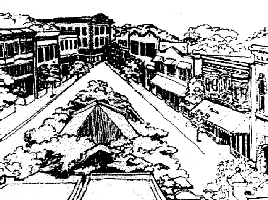
Point Richmond in 1913

Botts and His Flying Machine

The adventurous and enterprising nature of Point Richmond pioneers was embodied by Professor R. H. Botts, who established the "World's Aerial Navigation and Construction Company of Point Richmond, California". Professor Botts arrived here in 1900, announcing his intention to build two steam-powered flying machines which would make aerial expeditions to the North Pole. He built a model, and stirred people's imaginations with photos of the model soaring above Richmond. He convinced many local businessmen to buy shares, and began construction. On January, 1903, the machine with its "patented improved steam engine" was taken to the top of Nicholl Nob in preparation for its maiden voyage the following morning. But that night a storm blew in, forcing a premature abbreviated flight, head-first down to Glenn Avenue, where it landed in a heap. Botts' finances and his pride were in much the same condition as his machine. He left town quickly, never to know whether Botts and Point Richmond would have taken the place of Wright Brothers and Kitty Hawk in history, but for the forces of nature and the law of Murphy.

Botts

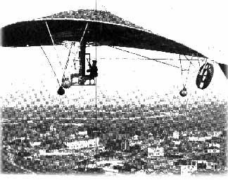
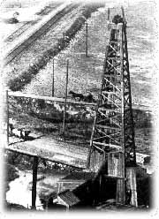
Bott's flying machine, superimposed over Point Richmond

Wetland Development...

Demand for land was so great that buyers didn't wait for the marshland to be filled. Poles with lot numbers on them were stuck in the mud, and purchasers waited for their land to appear. By 1905, the town was incorporated, and expanding rapidly. Enthusiastic developers called Richmond "the Pittsburgh of the West", predicting that it would become the greatest port on the West Coast.

The First Park...

Hard working pioneers needed recreation and relaxation. Early on, a Mr. Loomis created a bayshore park, which later on became Kozy Kove Resort. Loomis Park covered the beach area west of Keller's Beach, and continued up the hill. In 1906, after the Big Quake, many people came to the park just to sit and watch in amazement the eerie glow of the fire following the quake. Point Richmond received many refugees of the quake, housing them in local church basements. By that time, there were four churches, all of which are still standing, and all essentially the same as when they were built. Kozy Kove soon had bath houses and a dancing pavilion where bands played for weekend dances.

Brickyards...

Three brick companies were located in the Point. The red clay soil in parts of the Point made bricks called "the famous Richmond Reds". Largest, and latest to shut down, was the Los Angeles Pressed Brick Company (later called the Richmond Pressed Brick Company). Advertising the "finest fancy facing bricks anywhere", they provided the original paving material for the Bay bridges as well as many buildings in the area including the old Palace Hotel in San Francisco. The company operated until the late "60s, and bricks produced there can be seen on many Point buildings.

Looking up Washington
          Ave.

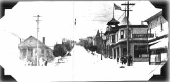
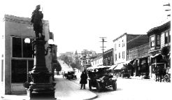
Looking up Washington Avenue

The Chinese Shrimp Camp...

Life in the Point became increasingly civilized, with milliners, tailors, dressmakers, department stores, bakeries, and even a candy maker. There were billiard halls, a bowling alley, the Opera House and small theatres showing silent movies. There were daily deliveries of milk, ice, and shrimp! The Chinese Shrimp Camp near Point Molate exported dried shrimp to China, and a man that kids referred to as "Shlimpy" made a daily trek across the hills with huge buckets of fresh shrimp on either end of a pole slung over his shoulders. He was an impressive sight, his gait causing the buckets to bounce up and down, alternately weighing him down and taking him off the ground, as he delivered shrimp to waiting housewives.

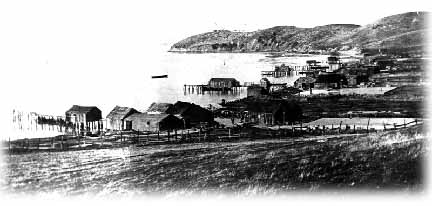
Chinese Shrimp Camp, 1904
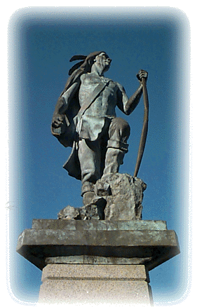
The Statue...

Refinements were needed in the young town, so in 1908, some ladies formed the Women's West Side Improvement Club. (It is still active in the Point.) They established a library, which eventually became a branch of the Richmond Public Library; they provided improvements to the small park called Janice Playlot, which had been sold to the City for a one-dollar gold piece by the Baptist Church next door; and they took on the project of providing public drinking fountains. They eventually decided on just one large fountain, to be erected at the apex of the downtown Triangle at Park Place and Washington Avenue. After considerable research, they selected a large fountain which could accommodate horses dogs and humans. Ordered from J.L. Mott Iron Works in San Francisco, it was unveiled in 1909, revealing an impressive Indian statue atop the large fountain structure. The statue presided over the business district until one night in 1943, when a local truck driver, leaving one of the local bars, backed into the fountain, knocking the statue to the ground. This was in the midst of World War II, when every scrap of metal was precious, and, as the story goes, city maintenance crews picked up the pieces, which were used either for the 'war effort' or for local repair parts. The fountain sat topless until, in 1984, local contributors funded a statue created by sculptor Kirk St.Maur.

Town.jpg (9514 bytes)

First Indian Statue

Winehaven...

The brick fortress at Point Molate was built by the California Wine Association. It became "the largest winery in the Universe", exporting wine to all parts of the world; even furnishing France, when that country suffered a drought. Winehaven was a popular spot. All visiting dignitaries were given a tour of the winery. When the Prohibition Law passed, all wine had to be disposed of. Tales of catching drunken fish by hand may or may not be true, but certainly the Bay was polluted in a way it has never been before or since, when tanks of wine were poured out. Wine bottles, too, were evidently thrown away, because glass 'pebbles' were collected for years by beachcombers. The Navy eventually took over Winehaven, making it a Naval Fuel Depot.

The Oil Well that Led to the Plunge...

John Nicholl, who owned a preponderance of Point Richmond land, was a promoter and entrepreneur who, in one case, found himself on the receiving end of a promotion. Smooth-talking C. L. Coffer came to town with his "Terrestrial Wave Detector". The apparatus, tied around Coffer's waist, detected oil in the Point Richmond hills. Choosing a spot at the base of the hills, now the yard in front of the "Plunge", Coffer convinced Nicholl to drill an oil well. Nicholl drilled, and drilled, until he met solid rock. Unwilling to admit defeat, he pounded through the rock while Point hills quivered. Eventually, he struck an artesian well, yielding 1,000 gallons per minute. This was capped off, and drilling continued for two more years, reaching down over a thousand feet. Bleachers were built around the fenced-in well, for spectators. In the meantime, harbor and tunnel bonds were passed by voters, and a tunnel through the hill allowing easier access to the Bay was planned. Nicholl's well was in the path of the planned road, but he refused to give up his project, which explains the commodious triangular intersection at Garrard, Cutting and West Richmond Avenues. Finally, in 1924, Nicholl gave up his plot to the city for an indoor swimming pool -- the Richmond Municipal Natatorium (The 'Plunge') -- which made use of the artesian well water. The Municipal Tunnel increased Kozy Kove's popularity, and led to the construction of a road to Brickyard Cove. The resultant lagoon between the road and the railroad tracks became a favorite "skinny dipping" spot for local boys. Their fun came to an abrupt stop one day when they saw returning cattle cars emptying their remains into the lagoon.

Oil Well

Nicholl's Well

A Little Reformation...

Those who grew up in the Point in those early days remember that Railroad Avenue was out-of-bounds. No 'decent' woman walked that street, either. By 1913, complaints by concerned citizens coincided with the passing of a State Red Light Abatement Act, and the Railroad Avenue bordellos were made illegal. Enforcement was convenient, since the jail behind the Firehouse was close at hand.

World War I, and Prohibition...

The First World War was at least partially responsible for the numerous independent, active older women residing in Point Richmond. It was a common practice during those years for companies to send their representatives to local high schools, to recruit girls prior to their graduation. With jobs so available, many young women found a relatively easy path to successful careers. During the Prohibition era, many of Point Richmond's Italian families managed to continue their custom of making their own wines, taking their equipment to basements or enclosed garages. However, the fragrance could have easily been detected, if an official came within smelling distance.

An Exodus...

During the 'Roaring '20s', it became popular to move to the more exclusive area called Mira Vista hills, which was farther away from the expanding Standard Oil refinery. And, in the Great Depression of the '30s, lots and houses here could be purchased by paying delinquent taxes. Even so, Point Richmond fared better than some other areas, largely because Standard Oil kept its employees by cutting back salaries instead of firing employees.

Burst and Bust: World War II and Beyond...

Realizing that Point Richmond was protected from smog and odors by incoming sea breezes, people again began building here. However, during the Second World War, Point Richmond boomed beyond capacity. The Kaiser Shipyards brought in workers from all over the country. Every available space was used to house wartime workers. Local Washington School, built to accommodate 350 students, bulged with 1500, attending in shifts. All local schools were conducted in shifts; people even slept in shifts, sharing apartments. Wartime housing popped up almost overnight, covering the flatlands along Canal Boulevard. Larger houses were divided into apartments. Local businesses flourished with frenetic activity. After effects of the war, however, were almost as devastating as a bomb blast. Empty and worse-for-wear apartments, shops and schools, trying to adjust to a 'normal' existence, brought a worn-out feeling to the town. Some shop owners retired, leaving empty hulls behind; some stayed, but felt no financial need to upgrade their buildings or businesses.

Back to the Old, on with the New...

Gradually, wartime housing was torn down, temporary school rooms were removed, and a few new businesses moved in. But Point Richmond seemed to be in a state of confusion during the fifties and even into the sixties. Some older houses were reconverted to single family dwellings, some became permanent apartment houses, often with absentee landlords. The "sleepy little village" was largely ignored in the growing metropolitan area of the East Bay. But it was gradually rediscovered by people searching for a peaceful place to live. Once again, Point Richmond became an active, cohesive, yet heterogeneous area. The wave of positive energy spread, and Brickyard Cove was developed in the early '70s. A Regional Park expanded from Keller's Beach to Ferry Point. New homes, condominiums, shops and high-tech businesses have changed the Point over the years. But, largely because residents valued the historic nature of the Point, and worked toward its inclusion in the National Register of Historic Places, Point Richmond retains much of its original charm

The author, Donna Roselius founded the Point Richmond History Association in 1982. She now lives in Oregon and was kind enough to update this history for us...we are grateful.

CLICK HERE to return to the Point Richmond History Association's Home Page


history.html was last revised 05/8/21